CITY OF HATTIESBURG STORM CENTER
NEWS & REPORTS
All reports are also posted on the City’s social media channels:
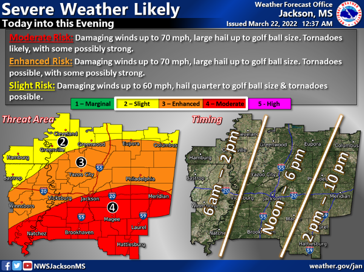
Weather Update | March 22, 2022
The Storm Prediction Center has placed all of the Pine Belt in a Moderate Risk (4 out of 5) for severe weather today. This includes all of Forrest County. All modes of severe weather will be possible today. Damaging winds up to 70 mph, large hail up to golf ball size and tornadoes will be likely with some possibly strong. The timeline for the expected severe weather has changed to 2pm to 10 pm. There is also a elevated risk (2 out of 4) for flash flooding today. 2 to 5 inches of rain is expected and this could cause some roads to become flooded. Outside of expected thunderstorms, the winds will be quite strong today. Sustained winds of 20 to 30 mph with gusts to 40-50 mph will be possible from 9 am to 9 pm.
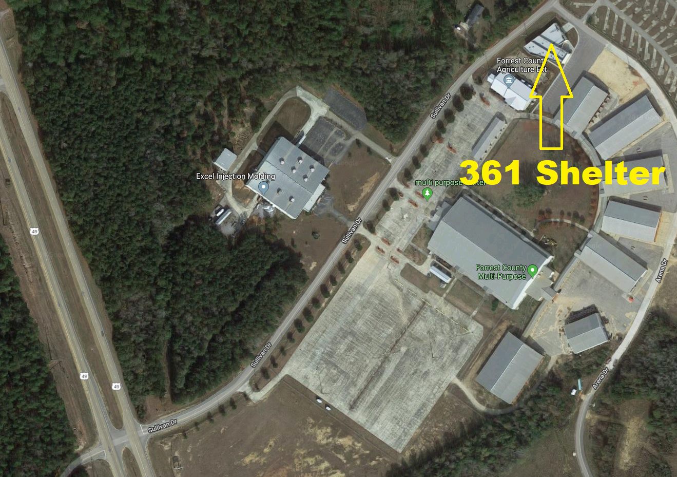
The Forrest County 361 Shelter will open at 10 am today and will remain open until the threat of severe weather has passed. The address for the shelter is 946 Sullivan Drive in Hattiesburg behind the Forrest County Multipurpose Center. A special thanks to the Salvation Army for providing lunch for those at the shelter.
Sandbags will be available at the Hattiesburg Fire Station #1 (810 Main Street in Hattiesburg) and Forrest County EOC (4080 US Hwy 11 in Hattiesburg).
Weather Update | August 26, 2021
- TD #9 is currently forecasted to become Hurricane Ida within the next 48 hours, as it makes its way into the Gulf of Mexico.
- Landfall is currently expected on the eastern Louisiana coast on Sunday night as a Category 3, with 115mph winds.
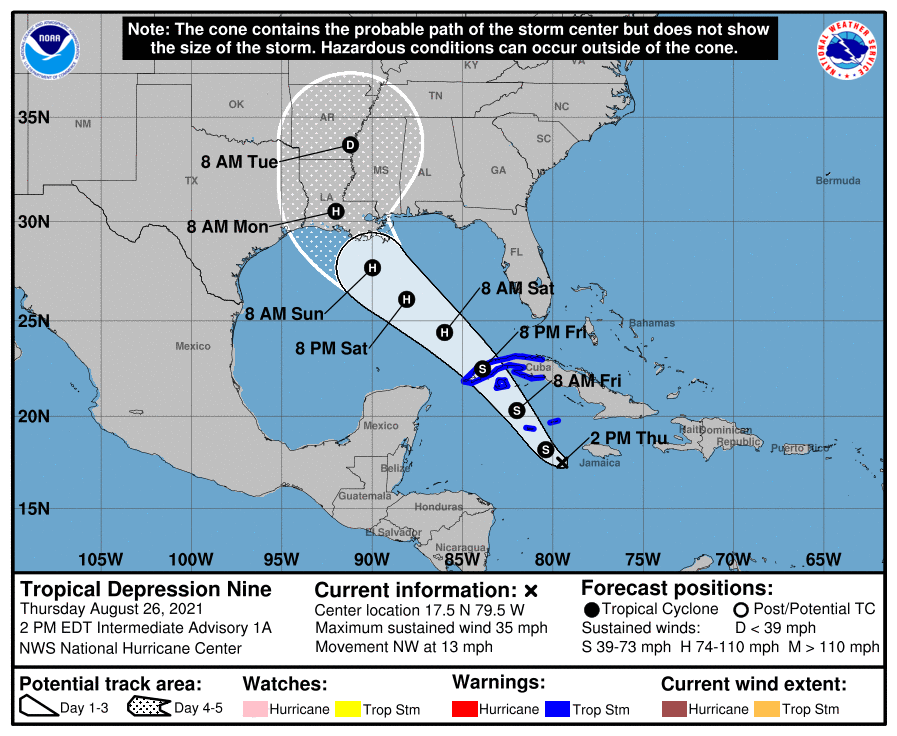
We’ll continue to monitor the system with both Forrest County Emergency Management and the US National Weather Service Jackson Mississippi
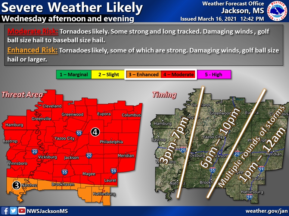
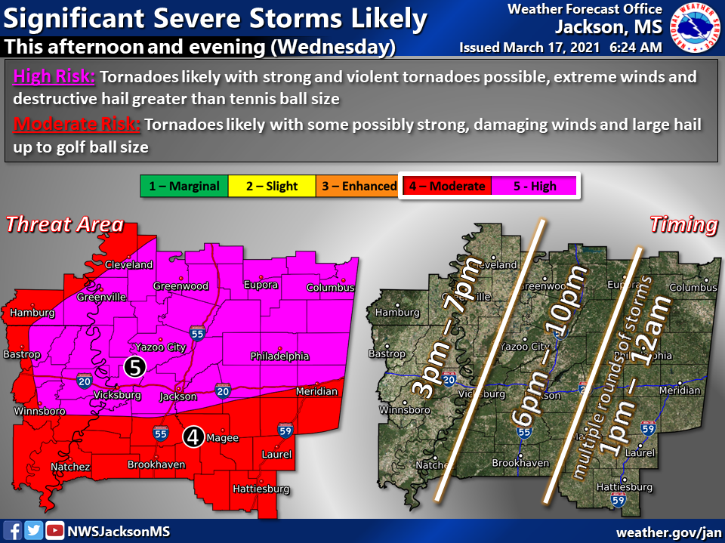
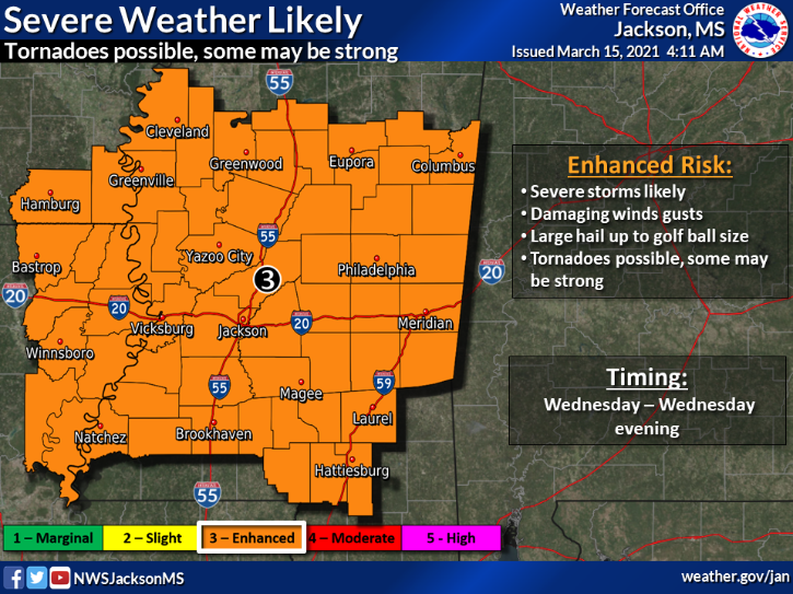
March 15, 2021; 11 AM
Hey, Hattiesburg. You have probably scrolled through several posts addressing severe weather for this week. At 72 hours out, the forecast will likely continue to evolve. However, now is still a great time to discuss severe weather plans with your family.
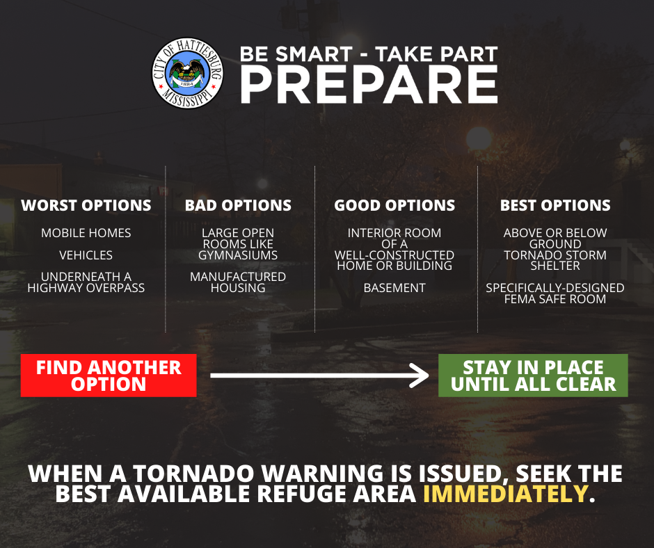
▪ Where will you take cover in the event a tornado warning is issued?
▪ If your property consistently floods during heavy rain systems, what can you do to minimize potential damage?
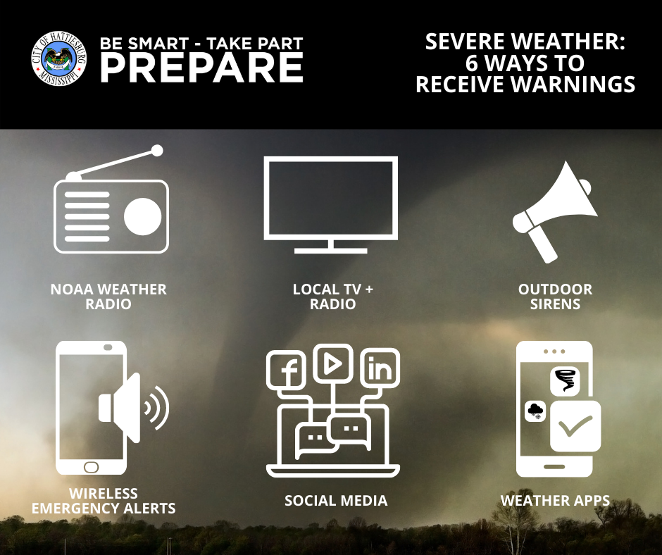
▪ Do you have batteries and extra charging ports to make sure all devices are fully charged?
▪ Do you have a way to be notified of severe weather in the middle of the night?
This means:
⛈ Severe storms are likely, with a possibility of golf ball-sized hail..
Damaging wind gusts.
Tornadoes are possible.
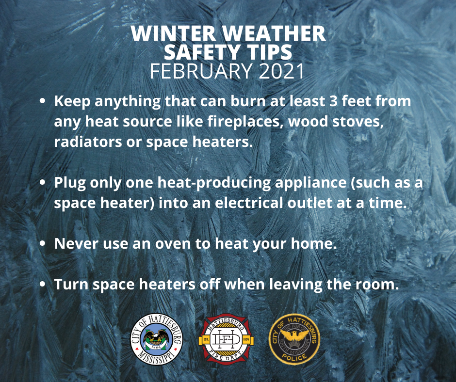
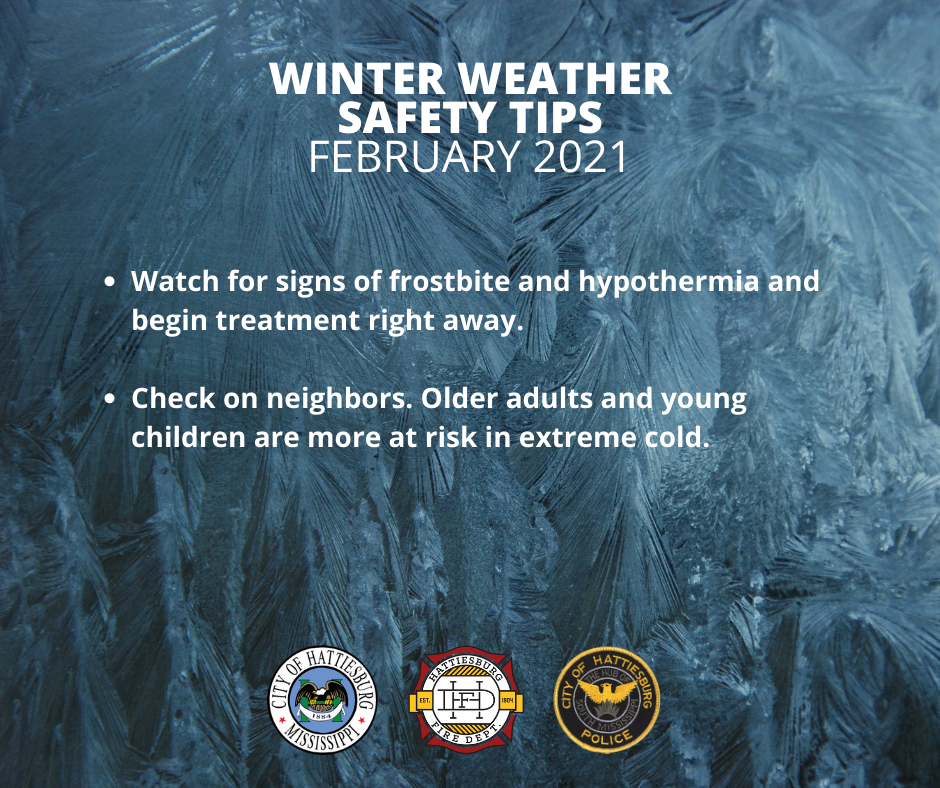
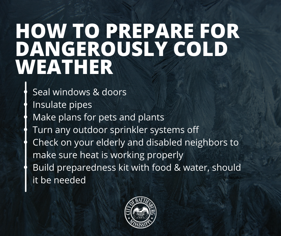
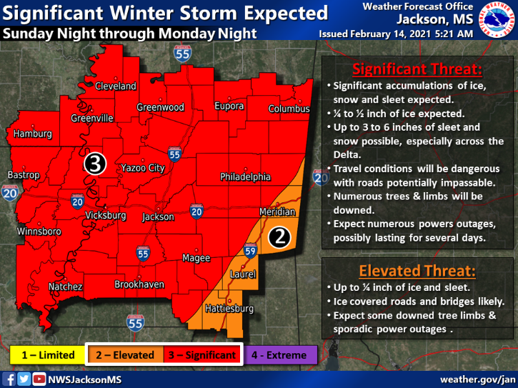
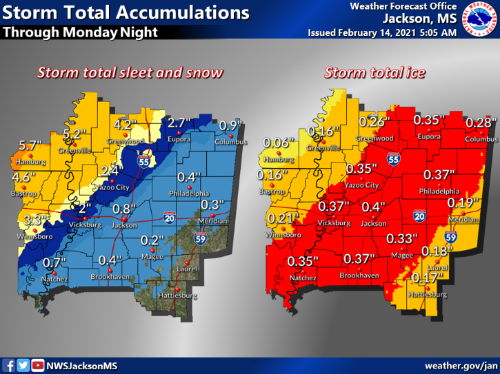
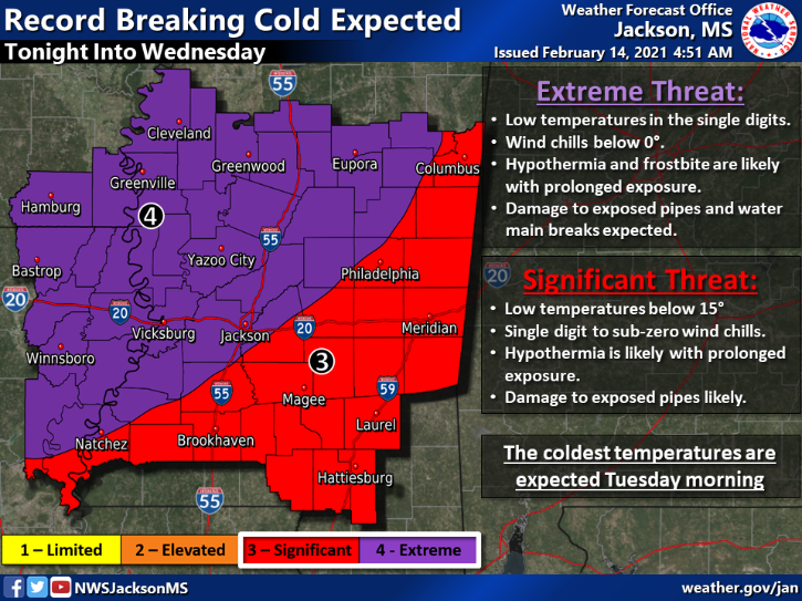
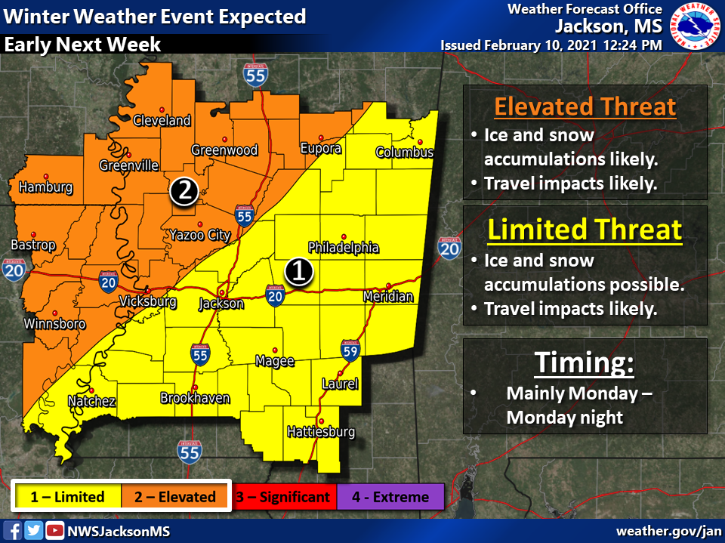
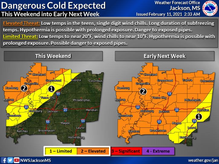
Monday, February 15, 2021 | 7 AM

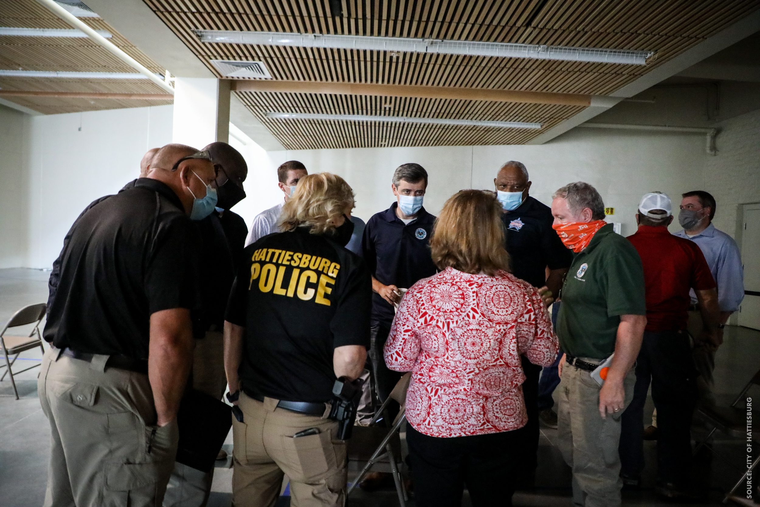
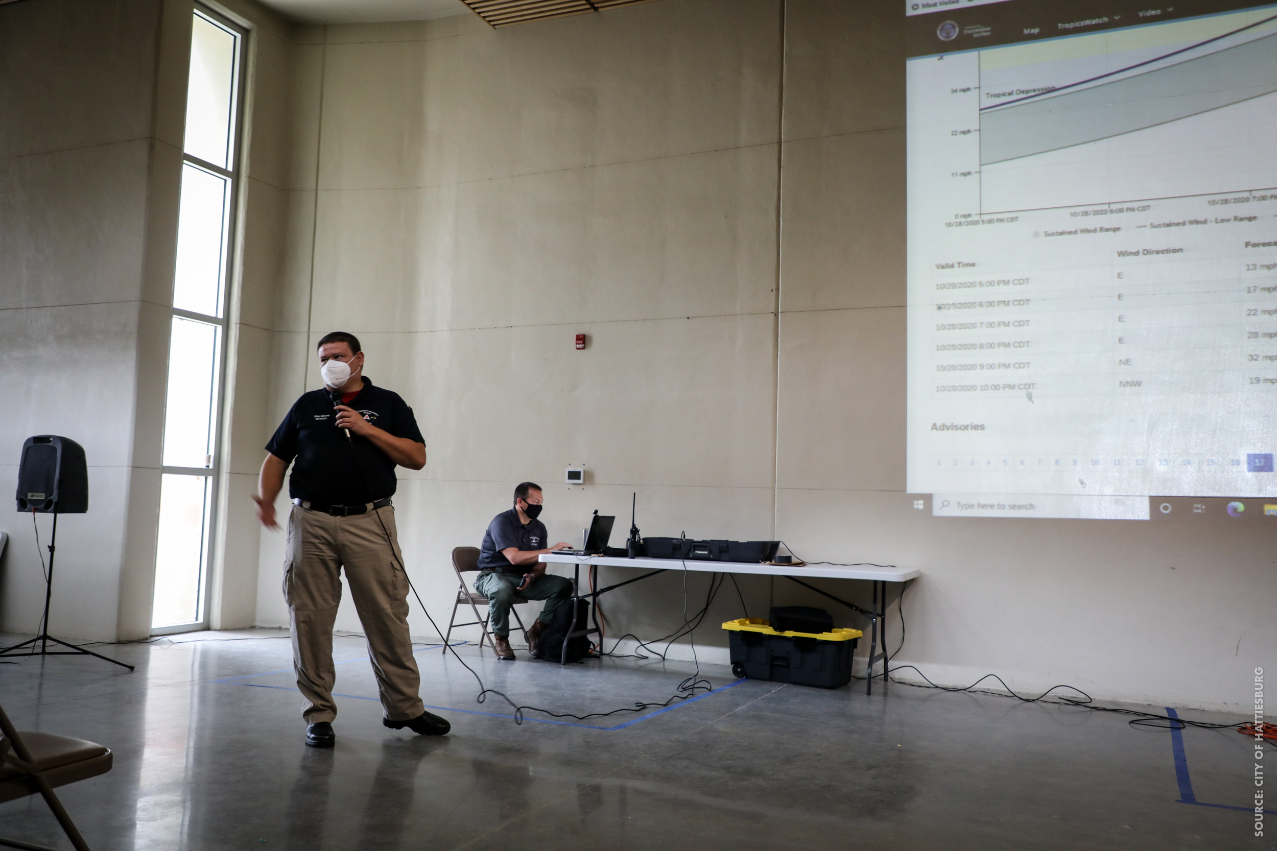
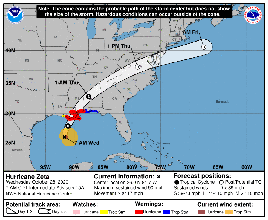
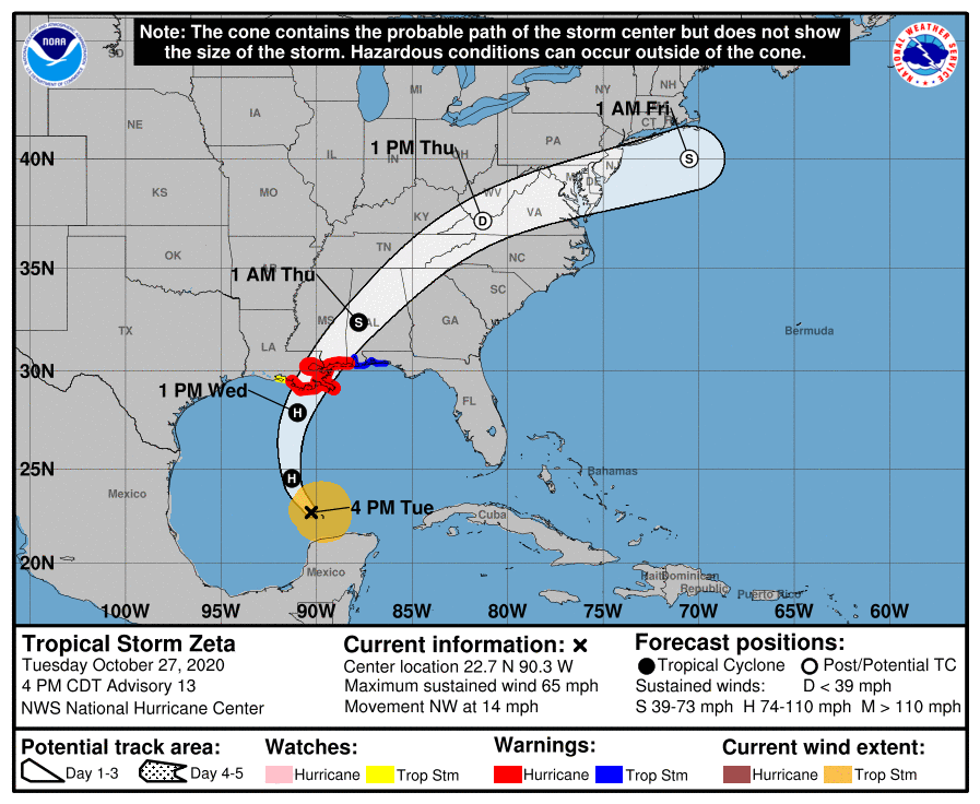
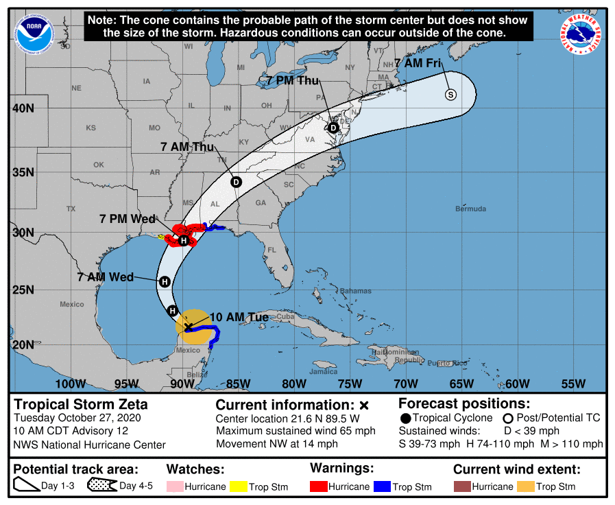
Wednesday, October 28, 2020 | NOON
Zeta’s track remains steady without much change. We know everyone has storm season preparation fatigue, but we’re in for a long day/night. Below are the highlights of what came from our 11 a.m. update with Forrest County Emergency Management.
- This will be a heavy wind and rain event for our area.
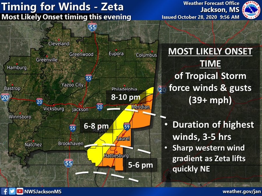
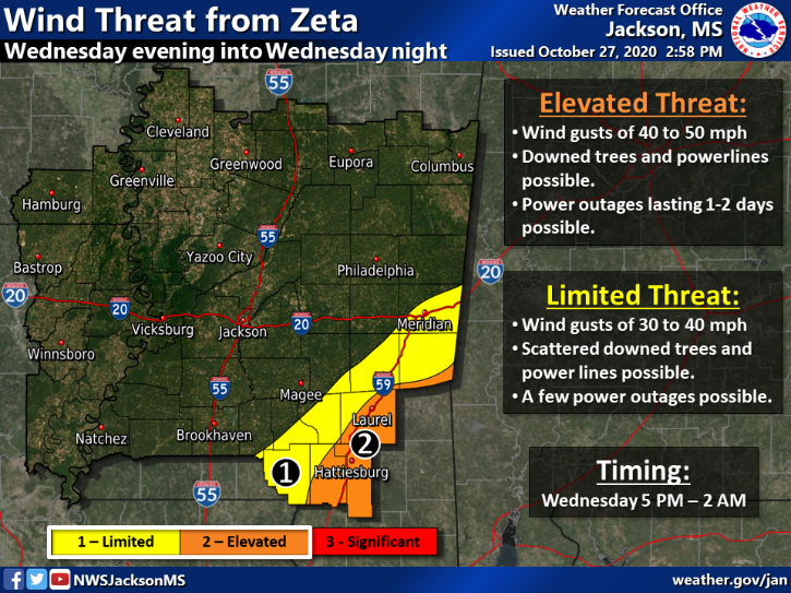
- Be off the roads by 5 p.m. Regardless of what category hurricane Zeta makes landfall at, the Pine Belt area is expected to receive tropical-storm-force winds beginning at 5 p.m. Attached is a wind-timing graphic.
- The City of Hattiesburg and Forrest County offices will close at 2 p.m., with the exception of public safety, dispatch and certain storm-preparation crews.
- Hub City Transit will stop routes by 5 p.m.
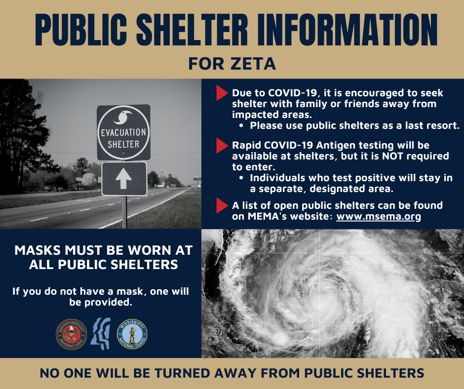
SHELTERING
- Sheltering is available at 946 Sullivan Drive beginning at 2 p.m. If transportation is needed, residents in the City of Hattiesburg can call 601-545-4500 and those in Forrest County can call the Sheriff’s Department at 601-544-7800.
- Masks are required at the shelter and COVID-19 precautions will be taken for all who seek shelter at this facility.
- Additionally – in partnership with MEMA, DHS and the MS National Guard – rapid COVID-19 testing will be available to all at the shelter. It is optional; however, should someone test positive they will take shelter in a separate designated safe room within the shelter.
WIND PREPARATION
- In preparation for wind gusts in excess of 85mph, all residents should bring in anything that can be a projectile during high winds. This includes garbage cans, patio furniture and Halloween decorations.
FLASH FLOOD WARNING & WATCHES
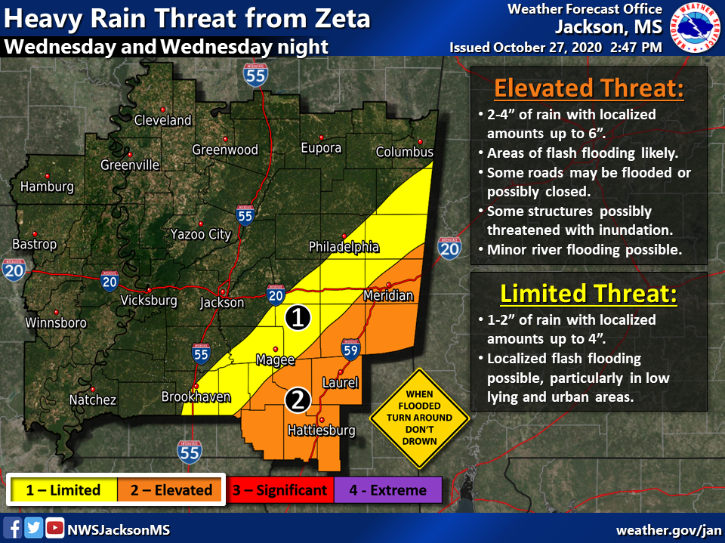
The Pine Belt is at an elevated risk for heavy rain up to 2-4 inches, with higher amounts up to 6 inches in low-lying areas as well as localized flash flooding.
- Don’t travel on the roads after 5 p.m. if possible.
- Do not travel through standing water.
- Obey all barricades/traffic signals/first responders.
MASKS & SANDBAGS
Masks and sandbags are still available at the following locations:
- Forrest Co. EOC (4080 US Hwy 11, Hattiesburg)
- Fire Station #1 (810 Main Street, Hattiesburg)
- Petal Fire Station (102 Fairchild Drive, Petal)
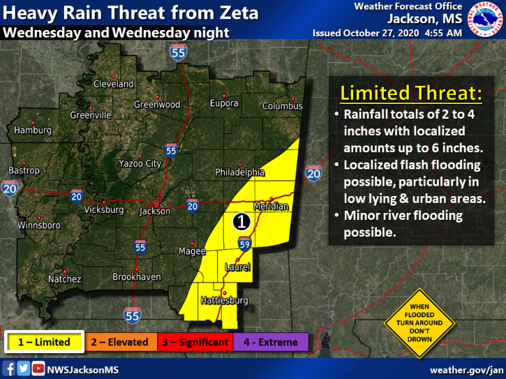
Wednesday, October 28, 2020 | 9 AM
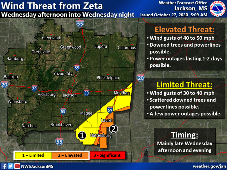
Zeta has gained strength and this morning’s forecast has slightly increased risks for the Pine Belt. The storm may strengthen slightly before making landfall and is forecasted to move through the area quickly.
Do not wait to make plans. This is expected to be a heavy rain event – along with the possibility of downed power and trees. Check on friends and family, make accommodations for sandbags, etc. if your home needs them and try to stay off of the roads this evening.
With the 9AM update, here’s what residents need to know:
- Zeta is expected to make landfall as a Category 2 Hurricane on the southeast Louisiana coast with a forward speed of 24mph.
- Forrest County and Lamar County remain under a Tropical Storm warning. Forrest County will also remain under a Flash Flood Watch until Thursday morning.
- Elevated risk for heavy rain up to 2-4 inches, with higher amounts up to 6 inches in low-lying areas as well as localized flash flooding.
- Elevated risk for high winds up to 85mph.
- Power outages and downed trees are likely.
- The timeframe is Wednesday night through Thursday morning.
- The 361 Shelter at 946 Sullivan Drive will be open at 2 p.m. TODAY. If you need transportation, you can call our action line at 601-545-4500 or the Forrest County Sheriff’s Office at 601-544-7800.
For masks or sandbags, they are available for free at these locations:
- Forrest Co. EOC (4080 US Hwy 11, Hattiesburg)
- Fire Station #1 (810 Main Street, Hattiesburg)
- Forecasted landfall is between the mouth of the Pearl River and the Mississippi/Alabama border late Wednesday evening.
- Forrest County and Lamar County are currently under a Tropical Storm warning.
- 2-4 inches of heavy rain, with higher amounts up to 6 inches in low-lying areas as well as localized flash flooding.
- Both Lamar and Forrest Counties may experience up to 50mph winds.
- Power outages are likely.
- The timeframe is Wednesday night through Thursday morning.
For masks or sandbags, they are available for free at these locations:
- Forrest Co. EOC (4080 US Hwy 11, Hattiesburg)
- Fire Station #1 (810 Main Street, Hattiesburg)
- Petal Fire Station (102 Fairchild Drive, Petal)
For masks or sandbags, they are available for free at these locations:
- Forrest Co. EOC (4080 US Hwy 11, Hattiesburg)
- Fire Station #1 (810 Main Street, Hattiesburg)
- Petal Fire Station (102 Fairchild Drive, Petal)
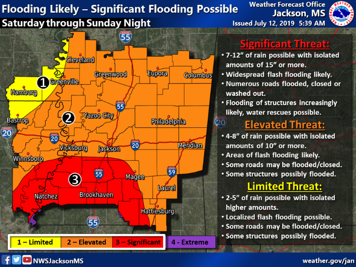
⛈ WEATHER UPDATE 7/12 | 4 PM:
Tropical Storm Barry is expected to make landfall in Louisiana, west of the MIssissippi Gulf Coast, during the morning hours of Saturday (July 13).
Hattiesburg is expected to receive between 4-8 inches of significant rainfall beginning Saturday, with the possibility of pop-up tornadoes. We’ll go under a flash flood watch at 7 a.m., at which time the Forrest County Emergency Management EOC will be activated.
Our area will experience rain bands and wind from the storm beginning Friday afternoon as the storm makes its way north.
Here’s what you need to know as we move into the weekend:
▪️ Free sandbags are still available (filled and self-serve) at the EOC 4080 US Hwy 11 (drive around back to the sandpile) and at Hattiesburg Fire Station #1 (self-serve only), 810 N. Main Street.
▪️ Free tarps are also available at the EOC. If your home has deferred maintenance on the exterior, you may want to pick up a few.
▪️ The 361 Shelter at 946 Sullivan Drive is currently on standby. If the EOC activates it, we’ll post that information here – along with transit opportunities if needed.
We know that the forecast may continue to change before it makes landfall, PLEASE be weather aware. Know which channels you’ll tune into (tv, radio & social media).
With the potential for flash flooding, we ask that you not drive on the roads during the height of the storm. HOWEVER, if you do – obey ALL barricades, road closed signs, traffic signals and first responders who may be assisting with traffic. Many swift-water rescues are deployed when motorists choose to go around signs or drive through standing water. You’ll hear us talk about this more than once throughout the next 48-hours. Help us, help you!
All significant road closures will be posted here throughout the height of the storm, and we’ll continue to share information with you as we have it.
Remember to…
1. Stay weather aware.
2. Be a good neighbor, check on friends and family.
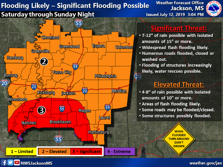
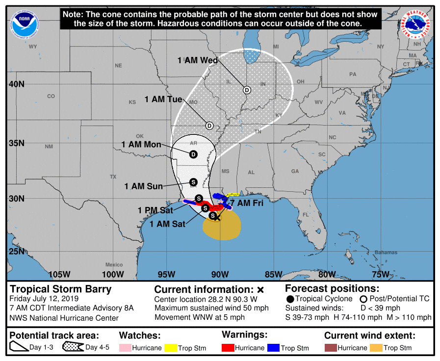
⛈ WEATHER UPDATE 7/12 | 9 AM:
Tropical Storm Barry’s track has shifted a bit west, and we are still at a significant/elevated threat for flash flooding on Saturday through Sunday.
Later today, we will begin seeing wind and rain from the outer bands of the system. As the forecast becomes more confident, we’ll post necessary updates about what that means for us in Hattiesburg.
A few additional notes include:
- Sign up for Hub Alerts —> http://hattiesburgms.com/hubalerts
- Charge all devices.
- If you live in an area that has the potential to flood with a typical rain system, be sure to have an emergency plan and communicate with your friends and family closest to you.
- Sandbags are still available at both the EOC (4080 US Hwy 11) and Fire Station #1 (810 N. Main St.).
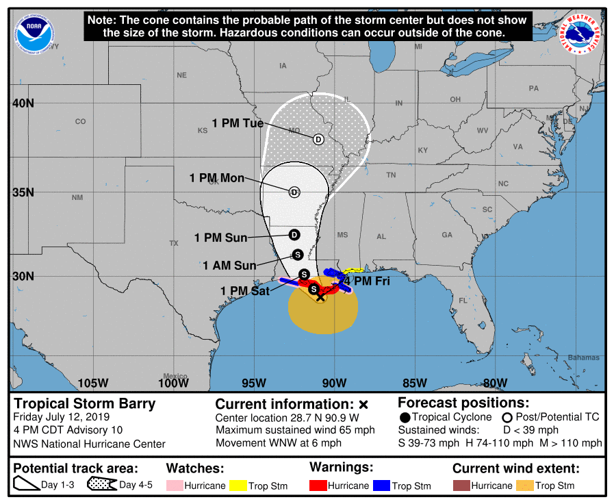
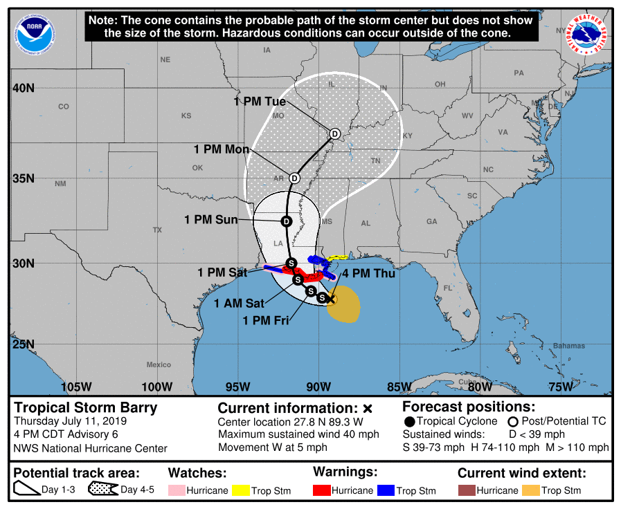
⛈ WEATHER UPDATE 7/11 | 4 PM:
According to the NOAA NWS National Hurricane Center, Tropical Storm Barry is forecasted to make landfall on Saturday morning (July 13)
What does that mean for us?
▪️ Beginning Saturday morning, our area will be under a flash flood watch until Sunday evening.
▪️ Our area may experience strong winds with the possibility of tornadoes and heavy rainfall that may cause flash flooding.
While the forecasts over the next 48 hours will be more confident, they will continue to evolve. PLEASE stay weather aware.
If you need sandbags to help with flooding, they are available at Forrest County Emergency Management (4080 US Hwy 11) and at Hattiesburg Fire Department‘s Station #1 (810 N. Main Street).
As a city, our departments have been preparing for the forecast and will continue to do so as we move into the weekend. We’ll post significant updates here.
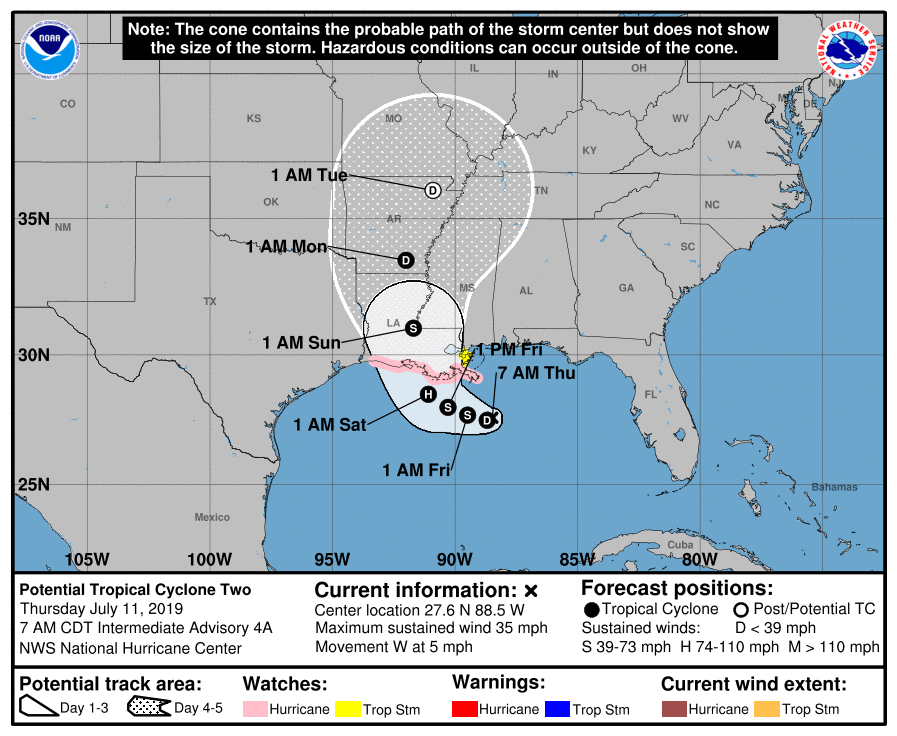
⛈ WEATHER UPDATE 7/11 | 9 AM:
The forecast for the tropical system in the Gulf did not change too much overnight, except for a small shift to the east for landfall. And at the 10 a.m. update, the storm was named a tropical storm (Barry).
Hattiesburg’s main threat will continue to be gusty winds with the possibility of pop-up tornados and flash flooding from heavy rainfall.
To prepare for any flooding that might occur, sandbags are available at the Forrest County Emergency Management office (4080 US Hwy 11). These are free.
Please remember, these tracks and forecasts will continue to change. We’ll post any significant updates here.
Reference Links:
National Hurricane Center https://www.nhc.noaa.gov/
Hattiesburg’s Storm Center www.hattiesburgms.com/stormcenter
Hub Alerts hattiesburgms.com/hubalerts
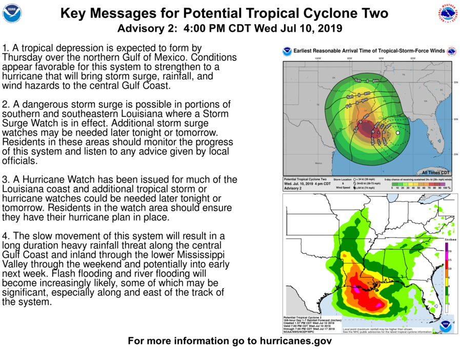
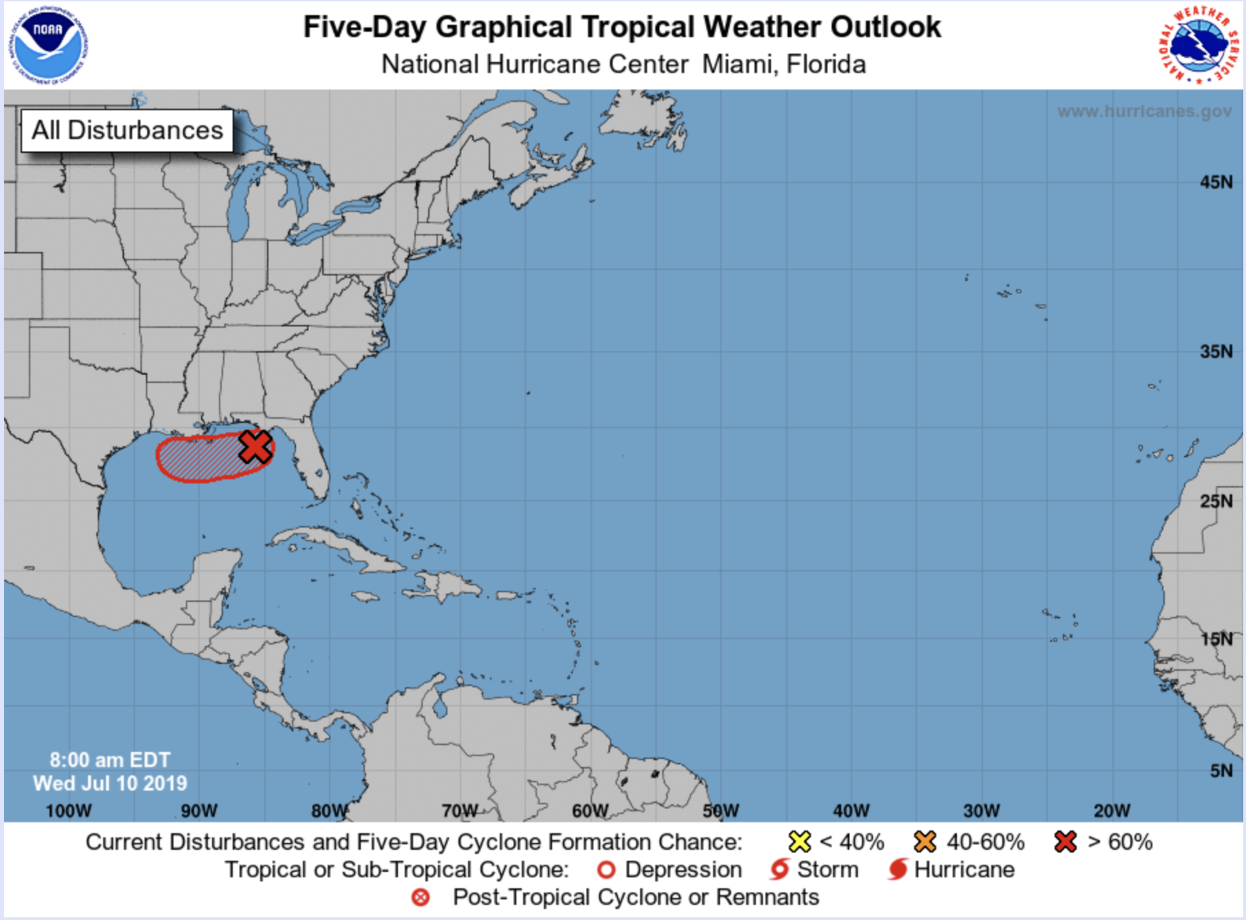
⛈ WEATHER UPDATE 7/10 | 5 PM:
The forecast for the tropical system in the Gulf has evolved and has been identified by the NOAA NWS National Hurricane Center as Potential Tropical Cyclone Two.
What does that mean for Hattiesburg?
Not too much has changed for us. We still have the potential to see heavy rainfall. We will be on the eastern side of the system, which puts us at a risk for flash flooding.
The storm is expected to form into a Tropical Depression by tomorrow (Thursday, July 11), with the possibility of being a Hurricane by landfall. If it develops, its name will be Barry.
Please remember, these tracks and forecasts will continue to change. We’ll provide all significant updates here, on Twitter (@Hattiesburg_MS) and on Facebook (@CityofHattiesburg).
Please stay weather aware, and have your plan ready to go should you need it.
⛈ WEATHER UPDATE 7/10 | 9 AM:
According to the NOAA NWS National Hurricane Center, there is an increased chance for a tropical depression to form late today or Thursday.
Here is what you need to know:
1. Tracks for tropical systems change quickly, and it is still too soon to determine what the magnitude or the location of impact will be.
2. Regardless of the track and intensity, our area will experience heavy rainfall in a short period of time. We know that means our area has the potential for flash flooding. Be prepared for that ahead of time.
3. If you aren’t already signed up for our community alert system – Hub Alerts – now is the time to do that. Text HBURG to 888-777 with your phone or fill out the form (with ways to add more contact information) by visiting https://www.hattiesburgms.com/hubalerts/. If we have to send out alerts beyond the weather warning, this will allow us to do that.
As always, we’ll be right here. We’ll post any updates that are significant to your well-being and safety.

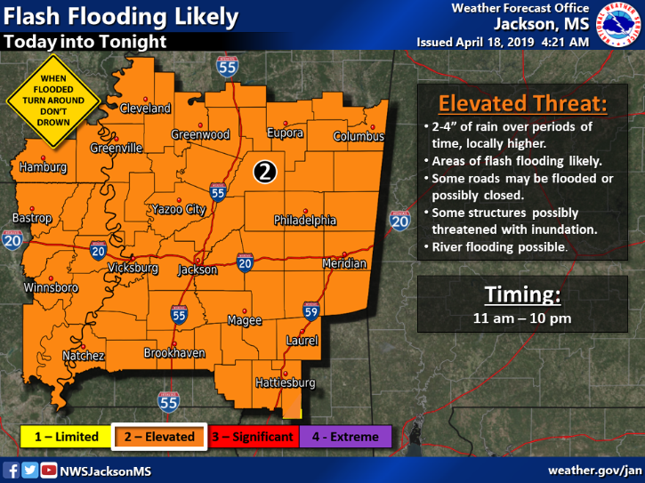
⛈ WEATHER UPDATE 4/18 | 1:45 PM:
US National Weather Service Jackson Mississippi has placed Hattiesburg/Forrest County under a Tornado Watch until 9 p.m.
A watch means that the weather event COULD happen. A warning means you should take cover now.
- Charge your devices.
- Touch base with friends and family regarding your emergency plan. Know where you can go if a warning is issued.
- Be cautious if you are on the road. Obey all barricades and officers who may be directing traffic where water is standing on the road.
The 361 Safe Room Shelter is open (946 Sullivan Drive) and sandbags are still available at Forrest County Emergency Management (4080 US Hwy 11).
Please stay weather aware, Hattiesburg.
⛈ WEATHER UPDATE (April 18 | 10:30 AM:
Due to the severe weather forecast, city offices will close at 3 p.m.
All response-based & emergency services provided by Public Works, sworn personnel & dispatch for the Hattiesburg Police Department (Official) and Hattiesburg Fire Department will continue operations.
Hub City Transit services will also continue until weather conditions don’t allow for such.
Sandbags to help with flooding are available at the Emergency Operations Center, located at 4080 US Hwy 11.
⛈ WEATHER ALERT (April 18 | 9 AM):
The forecast for this afternoon hasn’t changed much. The strongest of the storm will still occur between 4 p.m. and 8 p.m., but our area should begin seeing heavy rain around 2 p.m. With it, comes the risk of flash flooding.
Please be cautious while driving. Adhere to all traffic barricades and don’t drive through standing water.
Things to note:
Forrest County Emergency Management will open the 361 Shelter at 2 p.m. It is located at 946 Sullivan Drive (behind the Forrest County Multi-Purpose Center).
Ahead of today’s storms, the following institutions and organizations will dismiss early:
- Hattiesburg Public Schools (earliest at 12:10 p.m.)
- Lamar County Schools, 11:30 a.m.
- Pearl River Community College (all campuses), Noon
- The University of Southern Mississippi, 1 p.m.
- William Carey University, night classes are canceled.
The Earth Day Celebration at Town Square Park with the Downtown Hattiesburg Farmers Market has also been postponed until a later date.
Prepare for a bumpy day, and stay weather aware. We’ll post updates as we have them.
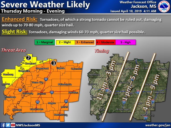
⛈ WEATHER ALERT (April 17 | 4 PM):
The Hattiesburg area is expected to receive a round of severe weather on Thursday, April 18. The current timeframe is forecasted between 4 p.m. and 8 p.m. On a scale of 1 – 5 for potential, we’re are at a 3 for enhanced risk. This comes with the potential of tornadoes, up to 70 MPH wind and hail.
Going into tomorrow, we ask that you do the following:
1️⃣ Know/review your safety plan with your friends/family. Have a safe space to move to should you need it. The timeframe is during drive time and this may affect your plan.
2️⃣ Make sure you have a way to receive weather notifications. Please don’t rely on one source.
3️⃣ Charge your devices.
4️⃣ Don’t be complacent. While the forecast can always change, we also know what a devastating blow severe weather can have on our community. Don’t underestimate it and make a plan.
We’ll continue to watch the forecast and post updates where necessary.
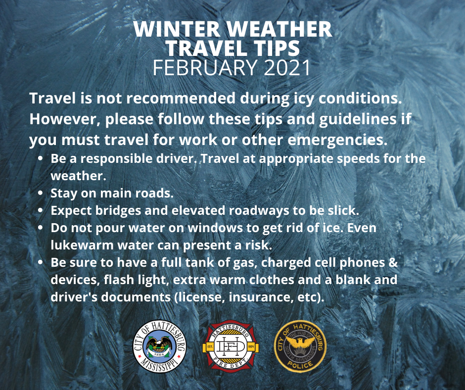
❄️WEATHER UPDATE (Jan 29 | 6 AM):
The roads are wet and snow is beginning to fall in some places. If you HAVE to be on the roads, please exercise great caution while driving. As for now, the system will move past us and will not affect travel.
❄️ WEATHER UPDATE (JAN 28 | 4 PM):
The latest forecast from US National Weather Service Jackson Mississippi and Forrest County Emergency Management is confident that Hattiesburg may receive up to one inch of snowfall. Updates include:
- Local schools, including Hattiesburg Public School District, will be closed on Tuesday, Jan. 29.
- Due to the forecasted conditions, the City will operate a delayed-start for offices at 11 a.m. However, all response-based and emergency services provided by Public Works, sworn personnel and dispatch for the Hattiesburg Police Department and Fire Department will continue daily operations. Pickup services (garbage & recycling) will still occur but will be delayed.
- Temperatures will drop through the night. The 361 Saferoom Shelter will open at 6 p.m. as a warming shelter and will be open through Wednesday at 10 a.m. Should residents need a ride to the shelter, he or she can call 601-545-4500. Any additional closures we hear of will be posted here.
❄️ WEATHER UPDATE (JAN 28 | 11 AM):
We are preparing materials should they be needed for the cold weather/icy forecast overnight through Tuesday morning.
We are currently working with our partners at Forrest County Emergency Management and US National Weather Service Jackson Mississippi to monitor the forecast, and we will follow their lead. We will meet with them this afternoon to discuss further preparations and response.
Below is what we do know from our partners at this time. Another update will be provided later this afternoon.
- Hattiesburg is at a limited threat for potential snowfall between 4 a.m. and 10 a.m. Light accumulation is possible. Travel conditions could become hazardous mainly on bridges due to snow cover and freezing of residual moisture.
- The Forrest County 361 Saferoom will open this evening as a warming shelter at 6 p.m. and will be open through 10 a.m. on Wednesday, Jan. 30.
- This forecast will continue to evolve as we get closer.
- All details will be added here, on Twitter (twitter.com/Hattiesburg_MS) and in our online storm center (hattiesburgms.com/stormcenter).
⛈ WEATHER UPDATE (1/3/19 | 3 PM):
Not too much has changed in the forecast for the afternoon/evening. We’re still expected to receive between 3-5 inches of rain in a very short amount of time, with rain continuing to fall through Friday morning.
Your drive home is going to be wet, and we REALLY need you to drive with extreme caution. Please adhere to the information below:
- Obey all barricades and signs. Last week we had to close more than 27 roads and intersections throughout the city due to the amount of water crossing the roadways. A full list of those roads can be found below (scroll to the bottom and click on Dec. 27 Flooding Event – Click for Archived Updates). We can’t say if we’ll have to do the same again tonight, but we encourage you to take a quick look through the list so that you can prepare for your commute home.
- If we do have to close roads, a running list will be provided here.
- Flash flood events already come with conditions that are dangerous. Flash flood events at night are even worse. Do not try to drive across standing water. If the road already has significant damage or a pothole is hidden beneath, you can cause serious damage to your vehicle or it can stall, leaving you stranded.
- Finally, get home and stay at home. This system could move quickly or it can stall. Either way, the best way to help us and our first responders is to get home and stay there until the system has moved through.
—
If you need sandbags, they can be picked up from Fire Station #1 (810 North Main Street) or the EOC office (4080 Hwy 11) on your way home.
Red Cross has opened a shelter at Petal Civic Center (712A South Main St) for any who need to seek shelter from possible flooding.
⛈ WEATHER UPDATE (1/2/19 | 2 PM):
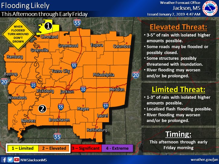 The US National Weather Service Jackson Mississippi is predicting another round of heavy rain beginning Thursday (Jan. 3) and moving through early Friday (Jan. 4) morning. Hattiesburg is forecasted to receive between 3-5 inches of rain.
As we saw last week, flash flooding can close many of our roads – quickly. With river/creek levels higher than normal due to last week’s rain, we’re asking everyone to be proactive.
- To prepare, sandbags can be picked up at Fire Station #1 (810 North Main Street) and at the Forrest County Emergency Management Office (4080 Hwy 11).
- Red Cross will open at shelter at Petal Civic Center (712A South Main Street).
- We’ll post periodic updates as we receive them, but please remember to adhere to all cautions and warnings. If you see barricades, obey them. They are out for your safety.
Forrest County EMA also still has teams assessing damage due to last week’s flood waters. If you had ANY damage, please contact 601-544-5911.
All updates, important information and resources can be located in the City’s online storm center at hattiesburgms.com/stormcenter.
 WEATHER UPDATE (12/29/18 | 10 AM):
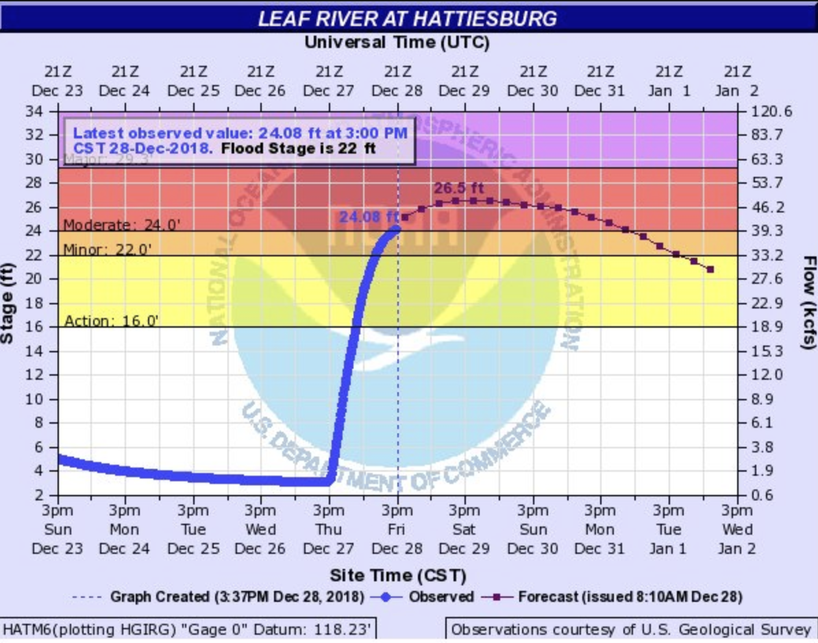
According to Forrest County Emergency Management and the US National Weather Service Jackson Mississippi, the Leaf River has crested at 24.62 feet (2 feet lower than forecasted).
The river level should slowly continue to fall throughout the remainder of the day.
The Red Cross continues to operate a shelter at the Petal Civic Center for those displaced by the flooding.
WEATHER UPDATE (12/28/18 | 3 PM):
COMMUNITY SHELTER IS OPEN
The Red Cross shelter is located at the Petal Civic Center, and it is open. It is located at 712A South Main Street in Petal.
NEED A RIDE?
If you need a ride to the shelter, please call the Action Line at 601-545-4500. It will be staffed throughout the night and into tomorrow.
SANDBAGS AVAILABLE
If you would like to pick up sandbags to protect your property against potential flood damage, they are available at Fire Station #1 at 810 North Main Street in Downtown Hattiesburg.
Please note, this flood event will be quick. We anticipate that the waters will rise quickly and fall just as quick. Please adhere to all cautions and warnings.
Moderate flooding is ongoing on the Leaf River at Hattiesburg. The report below is from the National Weather Service in Jackson.
The river is currently at 24.08 ft and is expected to crest Saturday (December 29) at 26.5 ft. Below is a list of flood impacts for respective river levels.
WEATHER UPDATE (12/28/18 | 9 AM):
After a very long night of flash flood warnings, all have ended. If you have sustained damage to your home or business, please call 601-544-5911 to make a report. This will help Forrest County Emergency Management compile a complete report to submit to MEMA.
Due to the continuous rainfall, the US National Weather Service Jackson Mississippi has issued a flood warning for the Leaf River and the Bouie Creek.
▪️ Leaf River to experience moderate flooding.
▪️ Bouie Creek to experience minor flooding.
We’re also forecasted to receive more rain throughout the next several days. To assist with flooding, sandbags will be available at Fire Station #1 (810 North Main Street) and Forrest County Emergency Operations Center (4080 US Highway 11) beginning at Noon.
WEATHER UPDATE (12/28/18 | 6 AM):
All roads are back open.
You may still see cones out in a few places where water is still standing on the road. We advise that you continue to use caution during your morning commute.
WEATHER UPDATE (12/27/18 | 10 PM):
The latest update from National Weather Service of Jackson estimates 8+ inches (total) rainfall for our area. With the amount of rainfall received, river flooding is a possibility and a river flood warning has been posted:
- The Leaf River in Hattiesburg is forecast to crest on Sunday, December 30 at 20.5 feet which is below flood stage.
- Bouie Creek near Hattiesburg is forecast to experience minor flooding through Saturday, December 29.
We’ll continue to monitor with Forrest County Emergency Management District and post additional updates when necessary.
WEATHER UPDATE (12/27/18 | 8:45 PM):
The rain bands of this system will weaken & gain strength on & off throughout the night. Please follow these safety messages if water is rising around your home.
⛈ UPDATE (12/27/18 | 7 PM):
Your phone may have gone off or you may have heard via the news that NWS Jackson upgraded the flash flood warning to a flash flood emergency based on the amount of road closures and continuous rainfall.
Reminders for staying safe in a flash flooding situation:
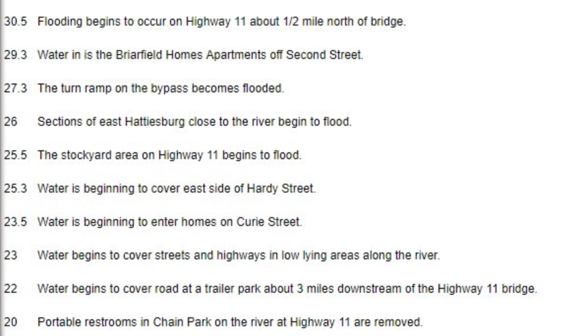
▫️ Do not walk, swim, or drive through flood waters.
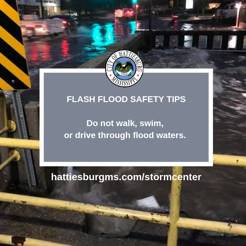
▫️ Stay off bridges over fast-moving water. Fast-moving water can wash bridges away without warning.
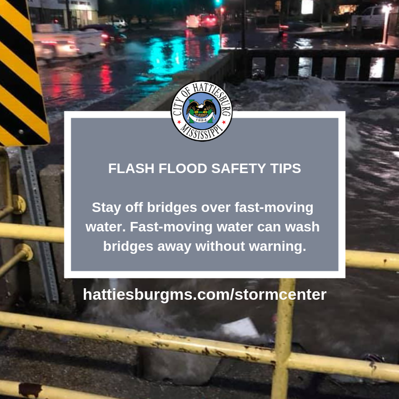
▫️ If your vehicle is trapped in rapidly moving water, then stay inside. If water is rising inside the vehicle, then seek refuge on the roof.
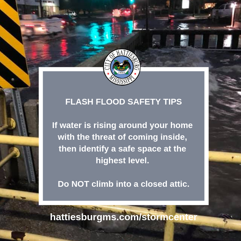
▫️ If water is rising around your home with the threat of coming inside, then identify a safe space at the highest level. Do NOT climb into a closed attic.
⛈ UPDATE (12/27/18 | 6 PM):
Please continue to use extreme caution if you are on the road. If you’re at home, stay put.
We’ll continue to get more rain throughout the night and into early Friday morning. The latest from US National Weather Service Jackson Mississippiindicates that we may receive up to seven inches total from this event. When we say stay home, we really mean it. Please take care of you and your family by adhering to all warnings and cautions.
This thread has garnered the most shares, so we’ll continue to edit it with updates as we receive them. Scroll to the bottom of this post for a running list of road closures and areas to avoid.
ROAD CLOSURES DUE TO FLOODING:
- Lincoln Road at 34th Avenue is now closed.
- 40th Avenue from Hardy Street to Lincoln Road is now closed.
- Providence Street is now closed with several stalled vehicles and rising water. HPD is currently on scene.
- Highway 49 at West Pine is now shutdown due to water crossing the roadway.
- West 7th Street is now closed from North Street to Main Street due to water crossing the roadway.
- Highway 49 Northbound near 4th Street bridge is shutdown. ‼️ 4:30 PM: This closure is NOW OPEN ‼️
Additional roads to avoid if possible due to water on roadways:
- 39th Avenue at Hardy Street (down to one lane)
- 16th Avenue at Hardy Street
- 7th Street at Hwy 49
- West Pine Street to Timothy Lane
- East Pine Street at Mobile Street
- Broadway Drive at Hwy 49 (HPD units on scene to slow down traffic)
- Hwy 49 at 4th Street (HPD units on scene to help with traffic)
- Edwards Street (water is across the road in several places)
- 300 Block of South 11th Avenue
- Park Avenue
- Weathersby Road at Turtle Creek Mall
- Highway 49 at Old Hwy 42
- West 7th Street at Main Street
- South 40th Avenue at Mamie Street
- West Pine Street between 2nd and 3rd Avenues
- South 21st Avenue, approaching O’Ferral Street
- Bay Street between Hall Avenue and Buschman Street
- South 40th Avenue at Jamestown Road
- Providence Street between 7th Street and 8th Street
- North 25th Avenue at 7th Street
- South 34th Avenue at W Adeline Street
- East Hardy Street at Oak Street
- West 7th Street at North Street
- Lakeview Road
⛈ WEATHER UPDATE (12/27/18 | 3 PM):
US National Weather Service Jackson Mississippi has issued a flash flood warning, and our area is predicted to receive up to 2-4 inches:
Remember:
1. Exercise caution and patience.
2. Don’t drive through standing water. Even if you *think* you can make it through.
And if you’re already at home, stay put until the worst of this system is behind us (please).
⛈ WEATHER UPDATE (12/27/18 | Noon):
Not too much has changed for this afternoon’s forecast by the US National Weather Service Jackson Mississippi, except for the shift in timing. Hattiesburg should see the heaviest of the storm between 3 p.m. and 10 p.m.
With it, comes heavy winds, possible tornadoes and an elevated risk for flash flooding. If you are traveling today, please use caution.
We’ll continue to monitor and post updates accordingly here, on Twitter (Hattiesburg_MS) and on Facebook (CityofHattiesburg).
⛈ WEATHER UPDATE (12/27/18 | 8:15 AM):
Hey, Hattiesburg. We’re in for a slight risk of severe weather today. This includes damaging winds with the possibility of tornadoes and an elevated risk for flash flooding.
If a tornado watch is issued, Forrest County will open the community shelter at 946 Sullivan Drive.
We’ll continue to monitor the weather with Forrest County Emergency Management District and update as needed.

LINKS & RESOURCES
WEATHER UPDATES
- National Weather Service – Jackson
- Forrest County Emergency Management District
- Mississippi Emergency Management Agency
- Mississippi Power Company – Power Outages & Storm Center
STORM PREPAREDNESS
-
- Floodplain Management
- Drainage Maintenance & Stormwater Management
- American Red Cross – Disaster Prep
- Cooperative Energy – Hurricane Safety & Preparedness Brochure
- Forrest General Hospital – Emergency Operations Plan
- MDOT – Hurricane Preparedness
- Pearl River Valley EPA – Severe Weather Safety
- Southeast American Disability Act – Emergency Preparedness
STORM RESPONSE
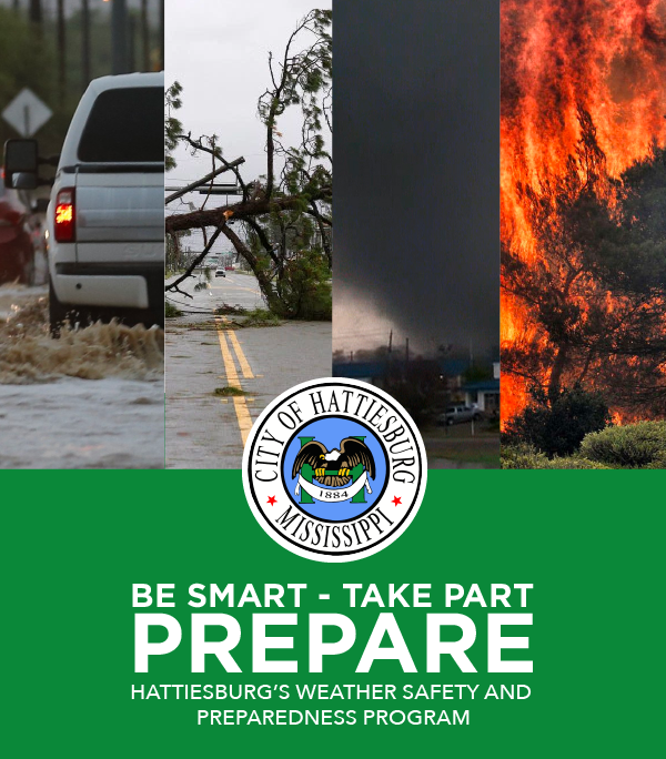
ABOUT THE STORM CENTER
Due to its proximity to the Gulf Coast, the City of Hattiesburg is no stranger to natural disasters. Leading up to, during and after – the City strives to provide concise and real-time updates to all citizens so that they may adequately prepare for what is to come and know where to go and what to do after a storm takes place. Often, we get questions about how the City will communicate and where information can be gathered. The City of Hattiesburg will use every method it can to communicate with those who live and work here to make sure they know what is happening and what they should be doing.
Should a disaster strike, methods for communication will include:
- This Website (hattiesburgms.com/stormcenter)
- Facebook (facebook.com/CityofHattiesburg)
- Twitter (twitter.com/Hattiesburg_MS)
- Local radio and television stations
- Action Line (601-545-4500)
- Emergency Alert System (learn more about HUB Alerts)
- In the event that the above methods are unavailable, messages will be physically posted on public buildings or used via loud speakers on police cruisers or other city vehicles will be used to communicate with residents.
During major emergencies, City representatives will be staffed at the Forrest County’s Emergency Operations Center.
EMPLOYEE COMMUNICATIONS
Communication among city employees is also critical when managing or responding to a disaster. The city will use any or all of the following methods to communicate with staff members at various city facilities and in the field. These include:
- Cell phones
- Two-way radios
- Emergency Alert System (learn more about HUB Alerts)